Exploring Our Planet
Human beings have always been curious about their surroundings. This curiosity has led us to discover mountains, deserts, oceans, and all the beautiful features of planet Earth.
Long ago, before mobile phones and the internet, travellers used globes and maps to find their way. Today, we still use them to understand our world better.
A globe is designed to be an almost-perfect copy of the Earth. We can use globes to take a closer look at all the beautiful and unique features of our planet or to locate a country, an ocean, and much more!
Continents and Oceans
If you look at pictures of the Earth taken by artificial satellites, you will observe large land masses surrounded by water. These land masses are called continents.
🌏 The Seven Continents
Largest
Smallest
India is the seventh largest country in the world. It is located in the continent of Asia.
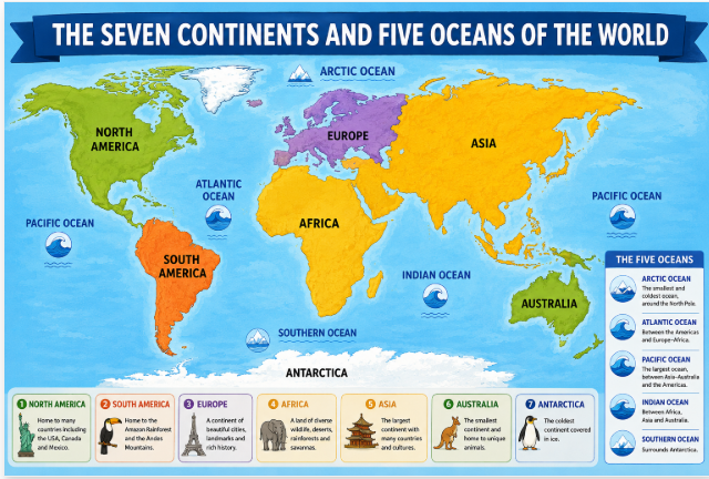
🌊 The Five Oceans
The large water bodies surrounding the continents are called oceans. There are five major oceans in the world:
Largest & Deepest
Also: Antarctic Ocean
Smallest
The Antarctic Ocean is also called the Southern Ocean. It is the newest ocean, named in the year 2000.
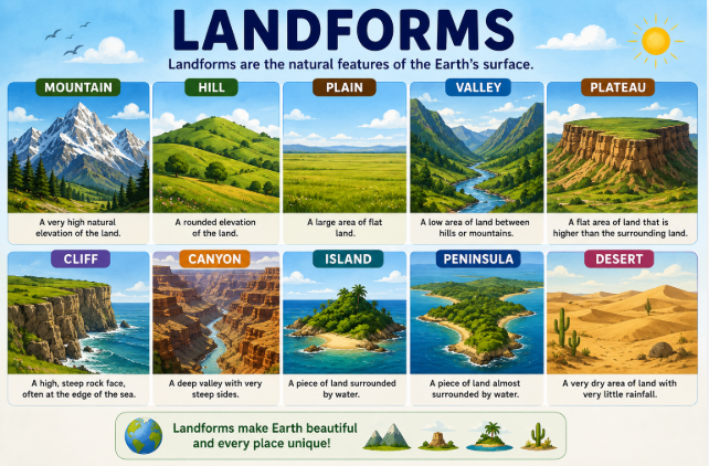
Besides oceans, the Earth also has smaller water bodies such as seas, gulfs, rivers, and bays. It also has landforms like mountains, plains, and plateaus.
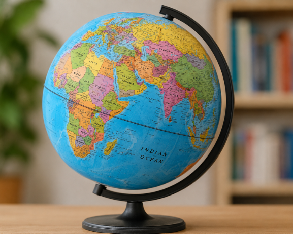
What is a Globe?
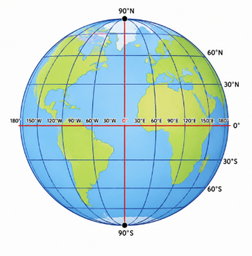
A globe is a three-dimensional miniature model of the Earth. A globe represents the Earth in a simple and accurate way.
We can only see one half of the globe at a time. A globe is not fixed — it can be rotated or turned, just like the Earth spins on its axis.
The axis of the globe has two end points called Poles:
- ⬆️The point at the top is called the North Pole
- ⬇️The point at the bottom is called the South Pole
Eartha was given the title of "World's largest revolving and rotating globe" by the Guinness Book of World Records in 1997. It took two years to build and weighs close to 2,500 kg. It represents the Earth as seen from space!
⚠️ Problems with Using Globes
Although globes give us accurate locations and shapes of continents and oceans, they have certain limitations:
- 👁️They do not allow us to see the entire Earth at a glance
- 🔍They do not show places and landforms in great detail
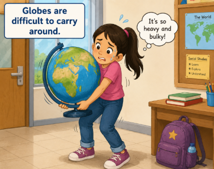
- 🎒They are difficult to carry around
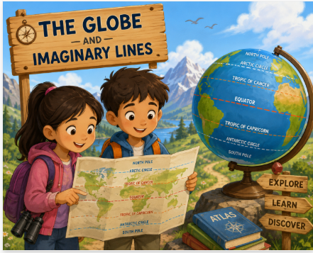
Horizontal Imaginary Lines
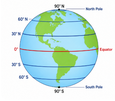
On looking at the globe carefully, you will see a set of circular lines running across it. These are called parallels or lines of latitude.
These are imaginary lines that run from east to west. The latitude that divides the Earth into two equal halves is called the Equator — it is the longest parallel.
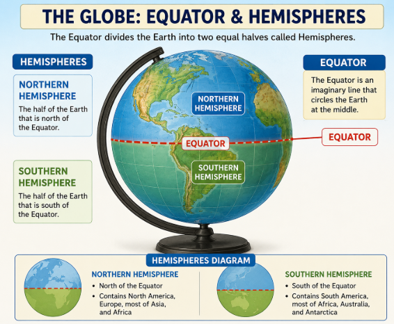
- 🌎The part of Earth north of the Equator is the Northern Hemisphere
- 🌎The part south of the Equator is the Southern Hemisphere
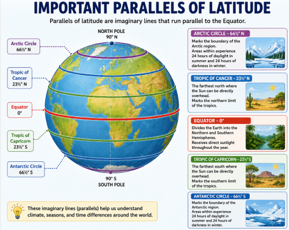
- 🔢Parallels can be drawn between 0° and 90° in either hemisphere. If drawn at 1° intervals, there will be 181 lines in total
✅ Features of Parallels of Latitude
- ⭕The parallels are complete circles, except at the North and South poles (which are just points)
- 📉The lengths decrease as you move away from the Equator towards the poles
- ↔️Parallels are located at an equal distance from each other. They do not touch or cut one another
- 0️⃣The Equator is marked as 0° latitude. Latitudes to the north are marked N; to the south are marked S
- 🔝The North Pole is 90°N and the South Pole is 90°S
⭐ Important Parallels of Latitude
Equator — 0°
Divides Earth into Northern & Southern Hemispheres. Also called the Great Circle.
Tropic of Cancer — 23½°N
Important latitude in the Northern Hemisphere
Tropic of Capricorn — 23½°S
Important latitude in the Southern Hemisphere
Arctic Circle — 66½°N
Northern polar region boundary
Antarctic Circle — 66½°S
Southern polar region boundary
The Equator is the most important latitude. It is also called the Great Circle.
Vertical Imaginary Lines
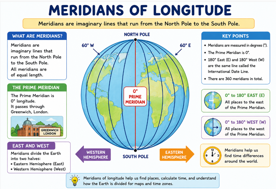
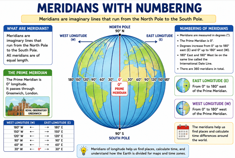
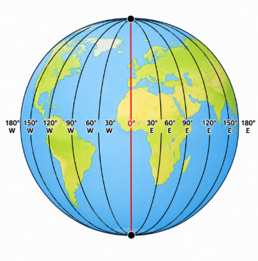
Did you also observe some lines running from north to south on the globe? These imaginary lines are called meridians or lines of longitude.
Meridians can be drawn anywhere between 0° and 180° east or west of the Prime Meridian. If drawn at 1° intervals, there will be 360 meridians of longitude.
✅ Features of Meridians of Longitude
- 📏The meridians are all of the same length
- ↔️The distance between any two meridians is maximum at the Equator
- 📉The distance between any two meridians decreases as one moves away from the equator towards the Poles
- ✂️The meridians cut the parallels at right angles (i.e., 90°)
- 🧭Meridians help to measure distances in the east-west direction
🌟 The Prime Meridian
- 0️⃣The Prime Meridian is 0° longitude. It divides the Earth into Eastern and Western Hemispheres
- 🔠Meridians to the east of the Prime Meridian are marked E; to the west are marked W
- 🌐The 180°E and 180°W meridians lie on the same line, halfway around the world from the Prime Meridian
Hungry Brains
An international conference in 1884 decided that the meridian passing through Greenwich in London will be called the Prime Meridian. The city of Ujjain was taken as the Prime Meridian by early Indian geographers. The 180° longitude is also called the International Date Line.
Using the Grid
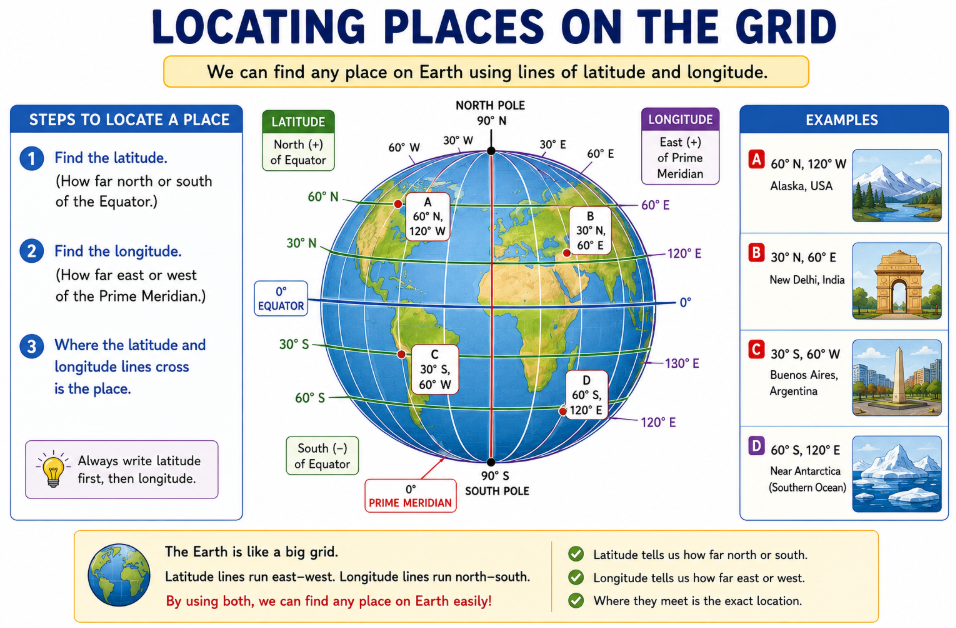
The parallels and the meridians intersect each other at right angles to form a network of lines. This network is called a grid.
The grid helps us to locate places on the globe. In order to locate a place, you need to know the values of both its latitude and longitude.
The point at which the latitude and longitude cross each other is the location of that place.
The latitude of Chennai is 13°N and its longitude is 80°E. The point where the lines passing through 13°N and 80°E meet each other gives us the location of Chennai.
Parallels vs Meridians
| Feature | Parallels of Latitude | Meridians of Longitude |
|---|---|---|
| Direction | East to West (Horizontal) | North to South (Vertical) |
| Starting point | Equator (0°) | Prime Meridian (0°) |
| Range | 0° to 90° (N or S) | 0° to 180° (E or W) |
| Total lines (at 1° intervals) | 181 lines | 360 meridians |
| Shape | Complete circles (vary in size) | Semi-circles (all equal length) |
| Measure | North-South distance | East-West distance / Time |
| Key line | Equator (longest) | Prime Meridian (Greenwich) |
🔁 Rewind — Key Points
- 1A globe is an exact model of the Earth.
- 2Parallels of latitude are imaginary lines that circle the Earth horizontally.
- 3The Equator is 0° latitude. It divides the Earth into Northern and Southern Hemispheres.
- 4The imaginary lines running from north to south are called meridians of longitude.
- 5The Prime Meridian is 0° longitude. It divides the Earth into Eastern and Western Hemispheres.
- 6The parallels and meridians intersect each other at right angles to form a grid.
Exercises
Practice what you've learned — answer each question below!
If you take a closer look at pictures of the Earth, you will observe large land masses surrounded by water. These land masses are called continents. There are seven continents on our planet. They are Asia, Africa, North America, South America, Antarctica, Europe and Australia. Asia is the largest continent, while Australia is the smallest continent. Each continent is divided into countries. Our country India is the seventh largest country in the world. It is located in Asia.
Keep trying!
Want to learn more? 🚀
Book a free 1-on-1 trial class with our expert teachers at Aviate Learnings!
Book a Free Trial → Student Enquiry Form